Posted on

Jurassic coast

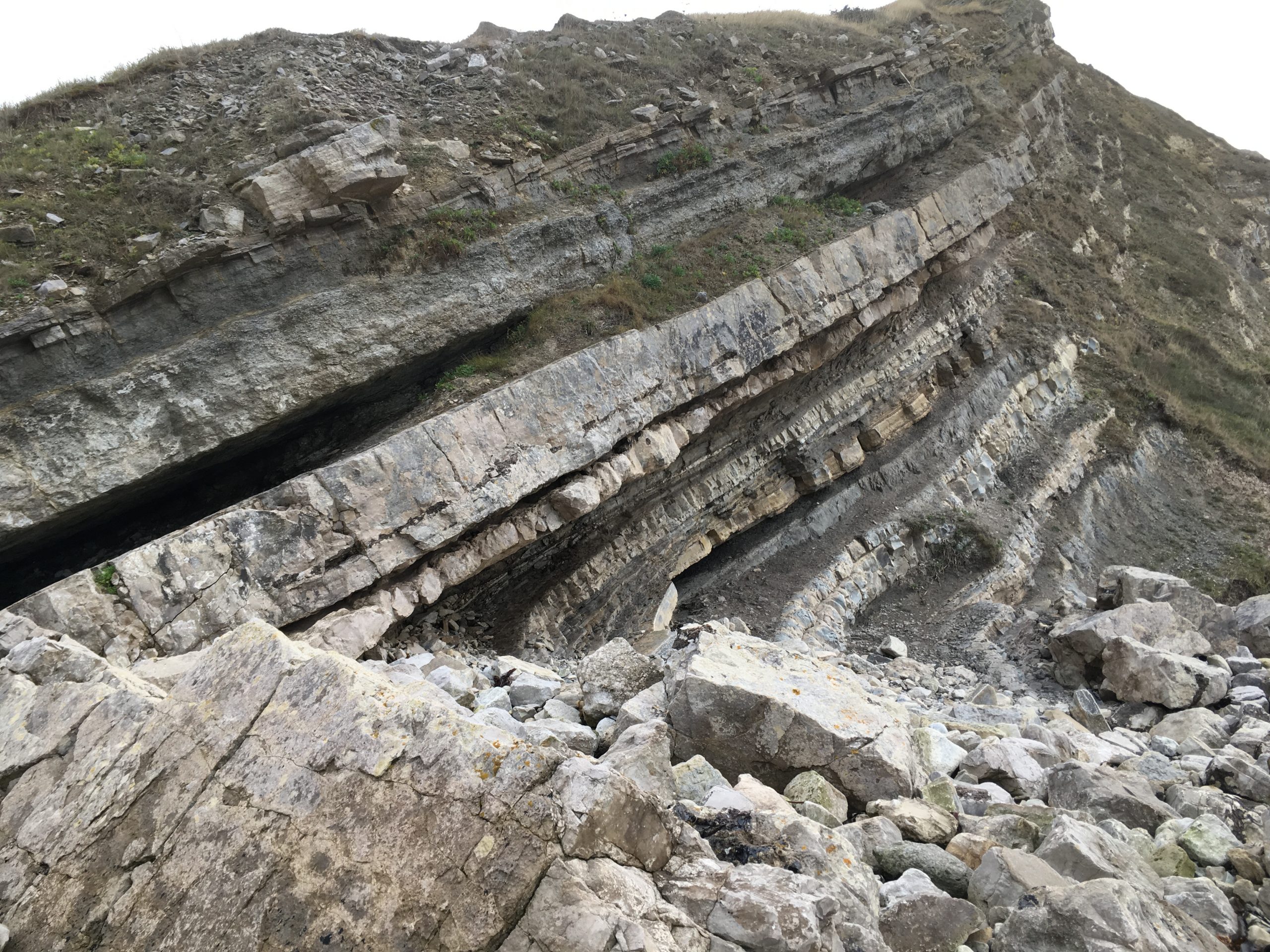
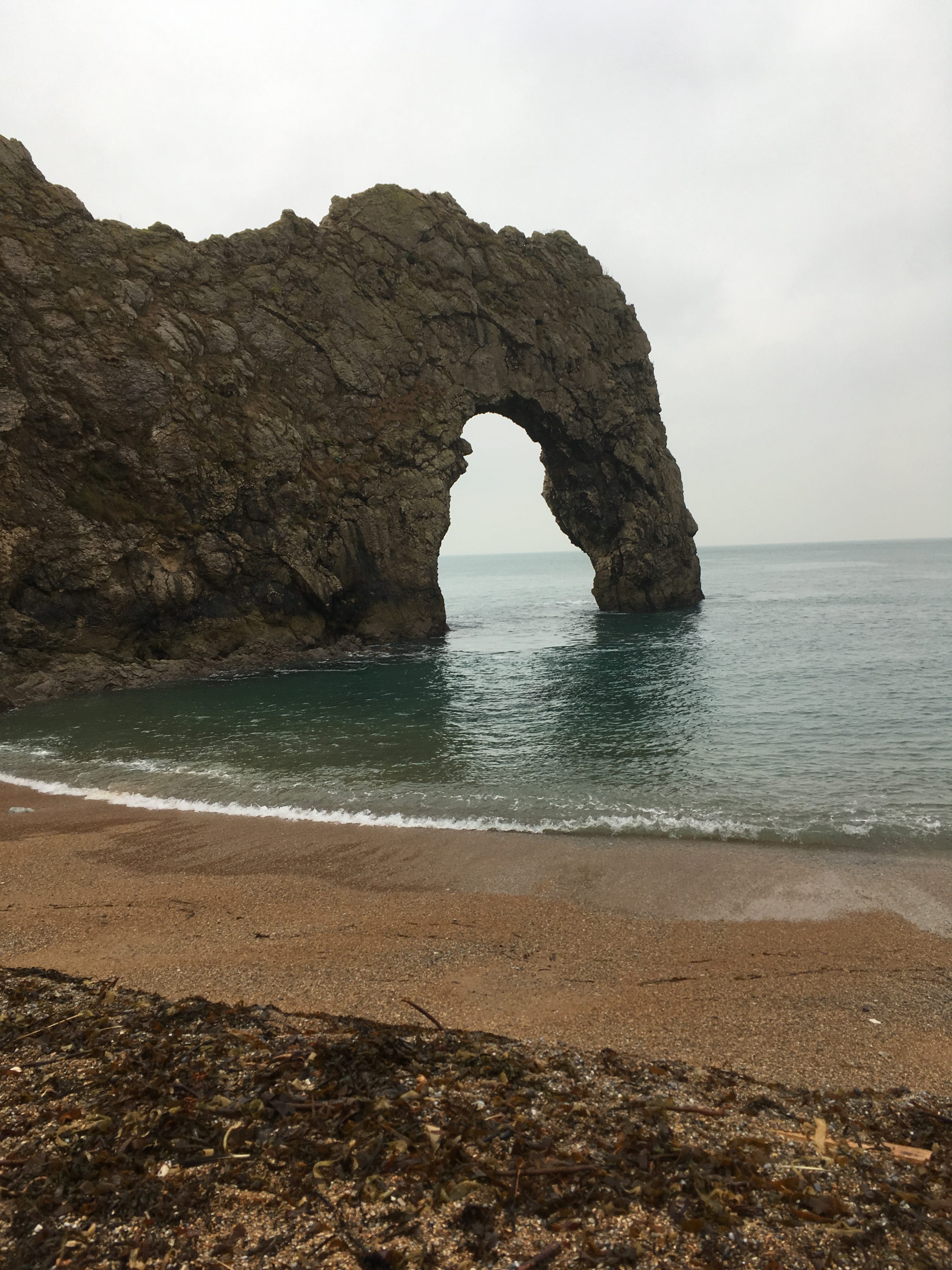
We recently visited the Dorset Jurassic coast, so named because it features layers of Jurassic limestone: 145 million year old Portland stone and Purbeck stone, as well as layers of Wealden clay, Greensand and Cretaceous chalk cliffs. Some of these layers contain fossil sea urchins and shells, and there is a even a fossil forest, with the remains of cypress tree stumps. The layers, or strata, have been uplifted and are now at a steep angle, some even vertical. The hard limestone has been eroded less than the clay, resulting in some unusual features like Durdle Door, a natural sea arch. Lulworth Cove is a perfect circle, where a river has cut through the limestone and the sea has come in and washed away the softer clay.

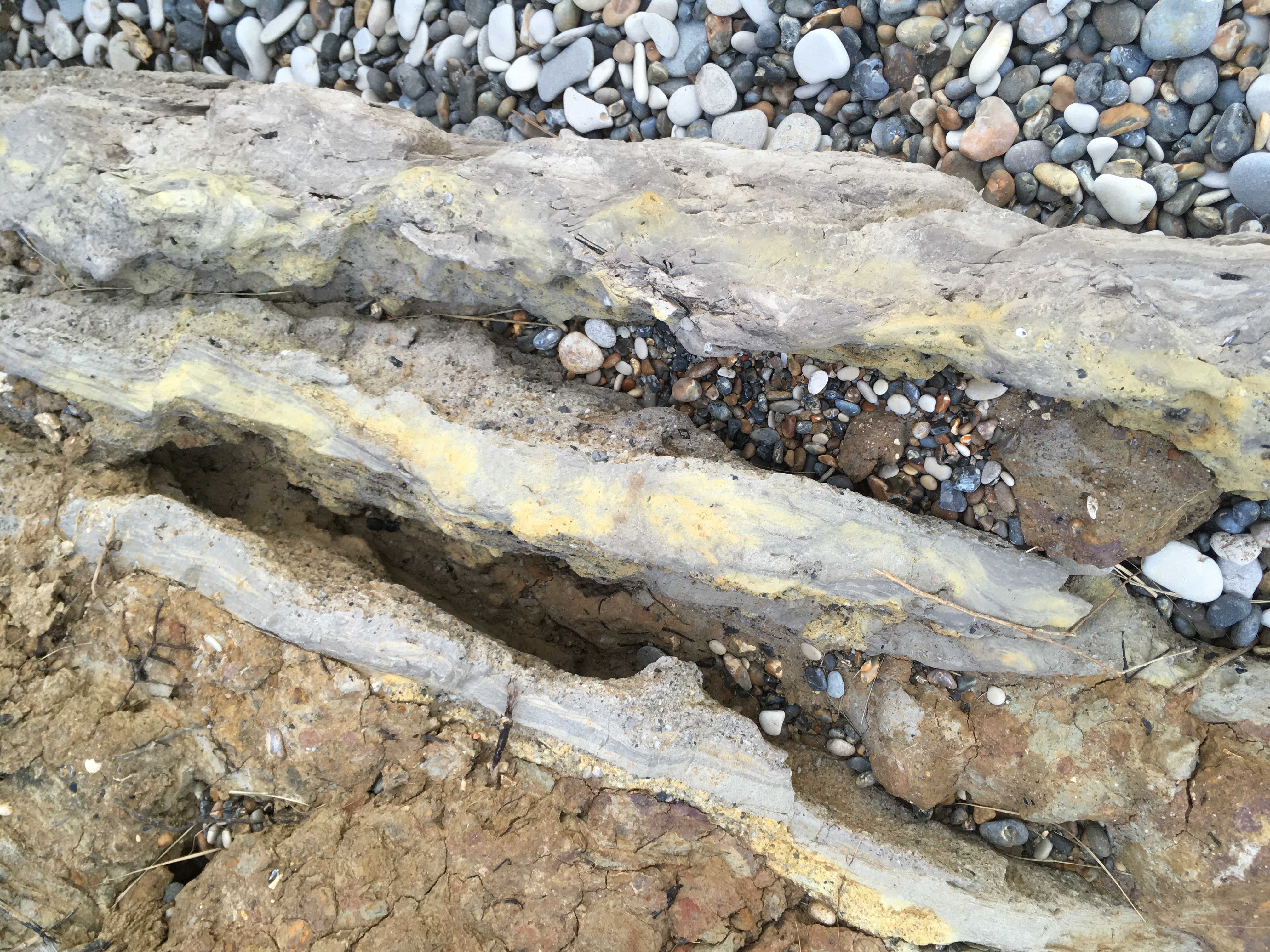
We collected some of the clay to make into a pinch pot. It was quite sandy clay and may contain too much calcium to fire above earthenware temperatures.

The layers of limestone are very thin because they were deposited in a shallow lagoon which frequently evaporated and dried up. The chalk cliffs are much thicker because they were deposited when the sea was relatively deep. The pebbles on the beach are the flints which dropped out of the chalk cliffs as they were eroded by the sea. This took tens of millions of years, the pebbles gradually getting smaller until they became shingle and then sand. The chalk on the seabed reflects the light, making the sea look turquoise here even on a cloudy day.


Durdle Door.
Wealden clay layers at Lulworth Cove
Jurassic Purbeck limestone layers at Lulworth Cove
Chalk cliff with vertical layers
Fossil forest.
Posted on

Cornwall geology and pottery

During our summer holiday in Cornwall we had a lovely walk along the SW coast path from Perranporth to Portreath, passing several abandoned mines and spoil heaps, great places to look for rocks and minerals.

Cornwall, Godrevy lighthouse

We started our 12 mile walk at Perranporth, south of Newquay on the north Cornwall coast. At Cligga Head, we passed an abandoned tungsten mine, where they mined wolframite, a black mineral containing tungsten, iron and manganese. There was also a lot of greisen, decomposed granite, on the first step towards becoming china clay. While the granite mass was solidifying 300 million years ago, hot gases caused it to decompose. It is now easily weathered by the rain and sea and we could see white granules of quartz everywhere under the heather. The hot gases forced the granite up through cracks in the older Devonian slate rocks and caused minerals to dissolve and reform in seams. The ends of mine shafts can be seen in the cliff face, which is stained red with iron oxide.

Rocks and pebbles found on our walk. Bottom right, altered granite; the large white crystals are feldspar. Bottom left, turquoise rock stained with copper. Middle left, red rock stained with iron oxide. The black rocks and pebbles are Devonian slate (400 million years old), with white veins of quartz running through them.

Rocks from the SW coast path

At St Agnes head, there is a granite outcrop which has been weathered into a clay and sand deposit where clay is dug for the Leach Pottery. Further along the coast path is the remains of an old tin mine, Wheal Coates, where the chimney of the Victorian pump engine house still stands at the top of the cliffs. Tin ore was found in seams below sea level, and so water had to be pumped from the mine shafts. We tried throwing a rock down one of the old mine shafts and it took a very long time to hit the bottom.

We also had a lovely visit to the Leach Pottery in St Ives, where we were shown round the working studio by trainee potter Lexie Macleod. The potters use a mix of St. Agnes clay, ball clay from Devon and iron oxide to give the dark, toasted colour they want. They use several glazes, a green ash glaze, black tenmoku, a dolomite white and a white/orange shino. They often throw a hundred mugs in a day, which then take several more days to finish and add handles. Their outlets include Seasalt, who fund an apprentice, and David Mellor in London and Sheffield.

The Leach Pottery studio
Posted on

Geology and everything

I went to Bath at the weekend, walking from Bradford on Avon along the canal, then through a mile long railway tunnel cut into the limestone. In Monkton Combe we passed the house of William Smith, who made the first geological map of Britain in 1815. The map shows the white streak of oolitic limestone which Bath is built of. The limestone was formed during the Jurassic, by small, round accretions of calcium carbonate deposited at the bottom of a shallow sea. Either side of the limestone are layers of mudstone and fuller’s earth, a type of calcium rich bentonite clay. William Smith put money into a Bath stone mine, which unfortunately produced only inferior stone and he had to go to debtors’ prison. He was not recognised until old age as the father of British geology.


During the walk, we noticed many wild flowers which grow in chalk soils,  including Bath asparagus, ornithogalum pyrenaicum, which only grows in seven counties but is common around Bath and Bristol. The shoots used to be eaten as asparagus. In the grounds of Monkton Combe school, we saw bee orchids, ophrys apifera, which look like little brown bees with pink wings.

Bath asparagus
Bee orchid

In the Monkton Combe village churchyard was the grave of Harry Patch, the last surviving soldier of the First World War, who died in 2009 aged 111.

I was interested in how the underlying limestone has affected the landscape, the flowers that grow there and the birds and animals. During the walk we heard chiffchaffs, saw a kestrel carrying a mouse, passed ducklings and dragonflies, as well as yellow irises, purple hedge woundwort and pink geranium pyrenaicum, hedgerow cranesbill.

We went through a very long, dark tunnel through the limestone hill, walked across Bloomfield Green and ended up in Bath, the city made of beautiful Georgian houses of cream coloured limestone.


Posted on 2 Comments

New book Science for Potters

science, potters, geology, chemistry, glazes, clay

I am excited that my next book Science for Potters is coming out soon. The cover shows a pair of Atomic Bottles by Kate Malone, covered with atoms and crystals. The book will cover chemistry, geology, clay, crystals, the science behind colour and glazes. For anyone who would like to know a bit more about the science of pottery.

Science for Potters


Have a look at an excerpt on silica phases and eutectics: Bloomfield_May17CM

Originally published in May 2017 issue of Ceramics Monthly, pages  80-81. http://www.ceramicsmonthly.org . Copyright, The American Ceramic Society. Reprinted with permission.

Posted on

Geology for potters

I am currently writing a book on Science for Potters for the American Ceramics Society. An extract on Geology for Potters has been published in Ceramics Monthly November 2015. Many potters use locally sourced clays and rocks in their clay bodies, slips and glazes. While researching for my book, I have become interested in geology and spent part of my recent holiday in Cornwall visiting clay mines and searching for rocks. My father used to take me on rock collecting expeditions to Aust Cliff under the old Severn suspension bridge, where we found quartz crystals and fossils. Aust Cliff is composed of layers of red mudstone and limestone.  You can see in the geological map below, it is part of the Mercia mudstone red clay shale deposit which stretches from the north of England coal beds down to the south coast. I recently visited an exhibition in  National Museum Cardiff  on the geological maps of William Smith, who first realised that layers of rocks were laid down in a sequence according to the fossils embedded in them.

You can read my article here:

Bloomfield_Nov2015

OLYMPUS DIGITAL CAMERA
Aust Cliff, photo Adrian Pingstone 2002
Map of clay deposits in UK
Map of commercial clay deposits in UK by Henry Bloomfield